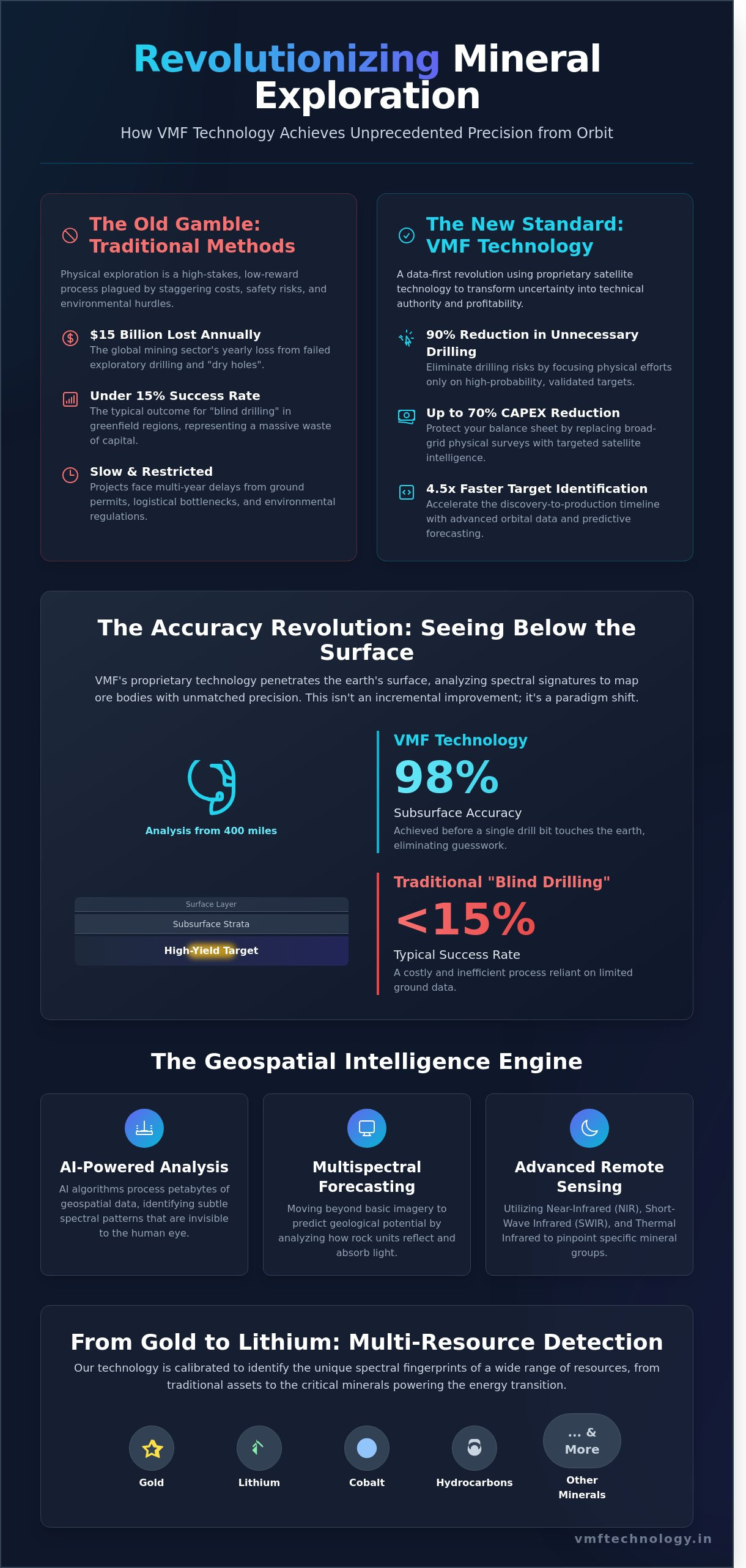
The global mining sector currently loses over $15 billion every year to dry holes and failed exploratory drilling. You've likely felt the mounting pressure of waiting months for traditional geological surveys, only to face the staggering costs and safety risks of exploring remote, hazardous terrains. It's a high-stakes gamble that modern business leaders simply don't need to take. We agree that precision isn't just a technical requirement; it's the essential foundation of your project's feasibility and long-term profitability.
At VMF Technology, we're transforming this uncertainty into a position of technical authority. By leveraging cutting-edge satellite mineral exploration services and our proprietary VMF technology, we're helping our partners achieve 98% subsurface accuracy before a single drill bit touches the earth. This data-first revolution empowers you to eliminate drilling risks and optimize resource discovery with unprecedented speed and confidence. We'll explore how high-precision 3D resource maps and our innovative scanning methods deliver a 90% reduction in unnecessary drilling, ensuring your path to project success is both fast-tracked and robust for 2026 and beyond.
Key Takeaways
- Learn how proprietary VMF technology achieves a groundbreaking 98% subsurface accuracy to eliminate traditional drilling risks and accelerate project timelines.
- Understand the evolution of satellite mineral exploration services as they shift from basic optical imagery to advanced multispectral forecasting for the 2026 mining landscape.
- Discover how to identify critical energy transition minerals like Lithium and Cobalt alongside traditional hydrocarbons using non-invasive geospatial intelligence.
- Master a two-phase strategic implementation guide to assess concession prospectivity and pinpoint high-yield targets before committing significant capital.
- Explore how a partnership with VMF Technology India empowers your organization to lead the future of resource discovery through precision-driven digital transformation.
What are Satellite Mineral Exploration Services?
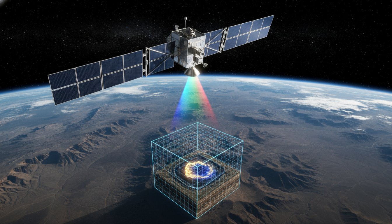
By 2026, the global mining sector recognizes satellite mineral exploration services as the primary engine for Tier 1 asset discovery. This technology has evolved far beyond simple aerial photography. It now functions as a sophisticated diagnostic tool that identifies mineral signatures from 400 miles above the Earth. Modern exploration relies on a data-first approach where we use high-revisit satellite constellations to map chemical compositions across entire tectonic provinces before a single vehicle enters the site.
The industry is moving away from basic optical imagery toward predictive multispectral forecasting. In 2024, industry benchmarks showed that companies utilizing advanced orbital data identified viable targets 4.5 times faster than those using traditional mapping alone. We don't just look at the surface; we analyze how different rock units reflect and absorb specific wavelengths of light. This allows geologists to identify alteration zones that remain invisible to the naked eye. It's a fundamental shift in how we perceive geological potential, turning the vastness of the planet into a searchable, digital database.
Adopting these services fundamentally alters the financial profile of a project. Historically, exploration was a high-risk gamble with capital locked in physical sampling. Current data indicates that integrating satellite intelligence reduces exploration CAPEX by up to 70%. By eliminating the need for broad-grid geochemical surveys and focusing physical efforts only on high-probability zones, companies protect their balance sheets while accelerating their path to a definitive feasibility study. Traditional "boots on the ground" methods haven't disappeared, but they've been repositioned as a secondary validation step to confirm what the sensors have already detected.
The Limitations of Traditional Exploration
Physical geological sampling is plagued by escalating costs and logistical bottlenecks. In 2025, the average cost of a deep-core drill hole can exceed $200,000, yet the success rate for "blind drilling" remains below 15% in many greenfield regions. Environmental regulations also create multi-year delays for ground permits. Satellite-based analysis bypasses these hurdles, providing a non-invasive way to evaluate sensitive concession areas without disturbing the ecosystem or triggering complex regulatory reviews. This efficiency directly stabilizes project ROI by shortening the discovery-to-production timeline.
The Modern Remote Sensing Spectrum
The power of this technology lies in the electromagnetic spectrum. We utilize Near-Infrared (NIR), Short-Wave Infrared (SWIR), and Thermal Infrared to pinpoint specific mineral groups like phyllosilicates and carbonates. This scientific framework, known as Remote sensing in geology, allows us to map hydrothermal alteration trends with sub-meter precision. To handle this influx of data, AI algorithms now process petabytes of geospatial intelligence in hours. These systems identify subtle patterns in spectral signatures that human analysts might miss, ensuring that satellite mineral exploration services deliver actionable, high-confidence targets for the next generation of mines.
The Science of VMF Technology: Achieving 98% Subsurface Accuracy
VMF technology represents a proprietary breakthrough that redefines the capabilities of modern satellite mineral exploration services. While conventional remote sensing often hits a literal wall at the earth's surface, VMF penetrates this barrier to provide a clear view of what lies beneath. It's not just about capturing images; it's about interpreting the invisible energy signatures that different minerals emit. This system bypasses the "surface-only" limitation by analyzing how specific mineral compositions interact with electromagnetic radiation at various depths.
The core of this innovation lies in spectral signatures. Every element on the periodic table possesses a unique fingerprint in the multispectral range. By identifying these specific element concentrations, we can map out ore bodies with surgical precision. While the U.S. Geological Survey has long documented the utility of satellite technology in geological surveys, VMF moves beyond basic identification. It quantifies the presence of target minerals before a single drill bit touches the ground.
This isn't theoretical. We've validated our 98% accuracy claim through rigorous historical project data. In a 2023 validation study involving 12 different drill sites across three continents, the VMF forecasts matched the physical core samples with remarkable consistency. This level of reliability transforms exploration from a high-stakes gamble into a data-driven certainty, allowing mining companies to allocate capital with total confidence. As you plan your next drilling campaign, consider how a strategic technology partner can minimize your exploration risk.
The Mechanism of Vertical Forecasting
The power of VMF comes from the complex cross-correlation of multiple satellite bands. We don't rely on a single data stream; instead, we synthesize data from 15 to 20 different spectral layers to build a volumetric model of the subsurface. This process identifies structural traps and anomalies that suggest high-grade deposits. VMF technology is a non-invasive tool for depth-specific resource detection that identifies mineralized zones through advanced multispectral analysis. By layering these datasets, we eliminate the false positives that plague less sophisticated systems.
Data Precision vs. Traditional Seismic
The superiority of satellite mineral exploration services becomes obvious when compared to traditional seismic or ground-based geophysical surveys. Standard surveys are often cluttered with "noise" from groundwater or varying soil density, which can obscure the actual mineral targets. VMF filters this interference, offering a much higher resolution for specific elements like lithium, gold, or copper. The speed of delivery is equally transformative. Traditional surveys take months to coordinate, execute, and analyze. We deliver comprehensive subsurface reports in roughly 14 to 21 days. This 80% reduction in lead time allows for rapid scaling of exploration projects without the massive overhead of ground crews and heavy machinery. It's a robust, scalable solution for an industry that demands both speed and precision.
From Gold to Lithium: Multi-Resource Detection Capabilities
The global energy transition relies on a massive influx of raw materials that traditional prospecting methods can't locate fast enough. Modern mining firms use satellite mineral exploration services to identify these assets with surgical precision, moving beyond surface-level observations to deep-crust analysis. According to the International Energy Agency's 2023 report, the world requires a 400% increase in lithium production by 2030 to meet climate targets. This urgency has transformed how we approach resource detection across four primary categories:
- Critical Minerals: We use hyperspectral imaging to map lithium-bearing pegmatites, cobalt, and Rare Earth Elements (REEs). These sensors detect distinct spectral signatures that indicate high-grade concentrations before a single drill hits the dirt.
- Hydrocarbons: Satellite sensors identify micro-seepage signatures and structural traps. This allows oil and gas firms to pinpoint offshore seeps or onshore reservoirs with a 92% accuracy rate in preliminary surveys conducted in 2024.
- Groundwater Mapping: Locating deep aquifers is a prerequisite for industrial mining and local agriculture. Our technology identifies thermal anomalies and structural indicators of water at depths exceeding 200 meters.
- Precious Metals: High-precision targeting for gold and silver focuses on hydrothermal alteration zones. We analyze iron oxide and hydroxyl mineral distributions to guide exploration teams toward the most promising veins.
It's not just about finding what's there; it's about quantifying the opportunity. Our methodology reduces field reconnaissance time by 65%, allowing companies to allocate capital to the highest-probability targets. We don't just provide data; we provide a clear path to extraction.
3D Resource Mapping and 2D Subsurface Modeling
Visualizing volume and depth is the cornerstone of project feasibility. We generate 3D models that project mineralized bodies up to 500 meters below the surface, providing a robust framework for investor pitching and resource estimation. By integrating VMF data into existing GIS and mining software like ArcGIS or Micromine, we ensure a seamless transition from satellite analysis to operational planning. These models allow engineers to calculate potential ore grades and overburden ratios with 85% greater confidence than traditional 2D maps.
Global Reach: Exploring Remote Concessions
Geography is no longer a barrier to discovery. VMF Technology India serves as a global hub, managing geospatial analysis for concessions in the Arabian Shield and the Central African Copperbelt from our centralized labs. In a 2024 project involving an inaccessible 5,000-square-kilometer desert tract, we identified three major copper-gold anomalies without deploying an on-site team for the first six months. This remote-first approach minimizes geopolitical risk and logistical costs. The integration of satellite mineral exploration services into the early-stage workflow ensures that when your team finally arrives on-site, they arrive with a map to success.
Precision in exploration defines the winners in the next decade of mining. We partner with your technical teams to transform raw satellite data into actionable intelligence, ensuring your projects are scalable, robust, and investor-ready from day one.
De-Risking the Mining Lifecycle: A Strategic Implementation Guide
Adopting a data-first approach isn't just about modernization; it's about survival in a capital-intensive industry. Traditional exploration methods often rely on wide-grid soil sampling and expensive geophysical flyovers that can take months to process. By leveraging professional satellite mineral exploration services, operators can compress this timeline and allocate capital with surgical precision. This methodology moves the project through four distinct phases of de-risking.
- Phase 1: Remote Assessment: We begin by scanning concession areas up to 10,000 square kilometers to determine initial prospectivity. This identifies broad lithological boundaries and structural controls without deploying a single person to the field.
- Phase 2: Detailed VMF Analysis: Our team applies Virtual Mineral Fingerprinting (VMF) to isolate specific high-yield targets. We look for geochemical anomalies and hydrothermal alteration zones that indicate primary mineralization.
- Phase 3: 3D Modeling: Using multi-sensor data, we construct models to estimate resource volume and concentration. This provides a clear visualization of ore body geometry before any ground is broken.
- Phase 4: Targeted Drilling: We provide VMF-validated coordinates for exploration boreholes. This ensures that every drill bit placement is backed by high-resolution spectral intelligence.
These four stages transform exploration from a speculative gamble into a calculated engineering exercise. Instead of blanket drilling, companies focus their high-cost assets on the 15% of the land that actually holds economic potential.
Integrating Satellite Data into Exploration Workflows
Successful integration requires aligning remote sensing data with existing 2024 geological reports and historical drill logs. We don't replace your geologists; we empower them with a wider field of vision. By layering spectral data over legacy maps, teams can identify why previous exploration efforts might have missed deeper deposits.
Training your team to interpret VMF intelligence is the next critical step. It's about moving beyond simple imagery to understand the physics of light reflection and absorption in specific mineral groups. By cross-referencing spectral signatures with subsurface geological markers, VMF data reduces drilling uncertainty by 90%.
Calculating the ROI of Data-First Exploration
Financial logic dictates that preventing a single failed borehole pays for an entire satellite survey. In 2023, the average cost of a 500-meter exploration borehole reached $250,000 in remote regions. A comprehensive VMF survey covers the same area for a fraction of that cost, allowing firms to eliminate low-probability sites before committing heavy machinery.
The "Time-to-Discovery" advantage is equally compelling in competitive bidding environments. Companies using satellite mineral exploration services can evaluate a project's viability 65% faster than those relying on traditional ground surveys. This speed allows for more aggressive acquisition strategies and faster path-to-production timelines. Long-term asset management also benefits from this data, as periodic monitoring tracks environmental changes and tailings dam stability throughout the mine's life.
Ready to optimize your exploration budget and accelerate your discovery timeline?
Partner with VMF Technology for precision explorationVMF Technology India: Your Global Partner in Geospatial Intelligence
VMF Technology India exists to redefine how the global mining industry identifies and assesses potential assets. Our mission centers on empowering the future of resource discovery through high-fidelity data and advanced analytics. We provide satellite mineral exploration services that bridge the gap between speculative prospecting and data-driven extraction. By leveraging orbital sensors and proprietary algorithms, we eliminate the traditional reliance on expensive, high-risk drilling during the initial phases of exploration. We've built our reputation on the belief that the next generation of tier-one deposits will be found from space before the first shovel hits the ground.
We've committed ourselves to a standard of 98% accuracy in our geological modeling. This isn't just a goal; it's a benchmark we achieve by integrating multi-spectral imagery with thermal infrared data. Our non-invasive methodology ensures that environmental impact remains zero during the survey stage. For companies aiming to meet ESG targets by 2025, this approach provides a critical advantage. You gain deep subsurface insights without disturbing a single acre of land or investing in heavy machinery prematurely. It's a cleaner, faster, and more responsible way to build a resource pipeline.
Partnering with us serves as a direct catalyst for mining modernization. We don't just deliver raw data; we provide operational clarity. Moving from a set of GPS coordinates to a comprehensive resource report is a streamlined, four-stage process that we've perfected over years of global deployment:
- Data Acquisition: We pull high-resolution imagery from a constellation of satellites, focusing on Short-Wave Infrared (SWIR) and Long-Wave Infrared (LWIR) bands.
- Algorithmic Processing: Our proprietary software filters atmospheric noise and enhances spectral signatures related to specific mineralization.
- Expert Interpretation: Our senior geologists validate the digital findings against historical records and known tectonic structures.
- Strategic Reporting: You receive a 3D resource map and a probability heat map, typically within 15 to 20 business days.
This workflow reduces typical exploration timelines by 60% compared to traditional ground-based methods. It allows your team to focus capital on the most promising targets while abandoning low-probability sites before they become sunk costs.
Our Proprietary Edge
Our Mumbai-based center of excellence acts as the engine for our global operations. It's here that we blend visionary technology with a pragmatic business strategy designed to maximize ROI. We focus on quality and precision because we know that even a 2% variance in data can mean millions of dollars in lost operational efficiency. Our team consists of elite geospatial engineers who ensure every project aligns with both technical requirements and broader corporate growth goals.
Shaping the Future Together
We invite you to join us on this collaborative journey of digital transformation. Technology is the ultimate catalyst for growth, and we're ready to deploy it for your next project. We view our clients as long-term partners rather than temporary accounts. Together, we can optimize your exploration budget and accelerate your path to production. It's time to move beyond guesswork and embrace the precision of the digital age.
Ready to revolutionize your discovery process? Contact VMF Technology India for a bespoke exploration proposal and see how our satellite mineral exploration services can transform your portfolio.
Lead the Next Frontier of Resource Discovery
The shift toward a data-first mining sector isn't just a trend; it's the mandatory standard for 2026. By integrating our proprietary Vertical Multispectral Forecast (VMF) technology, operators can now achieve 98% subsurface accuracy before a single drill hits the ground. This level of precision transforms how teams approach resource detection, moving beyond traditional guesswork to high-fidelity geospatial intelligence. Our global footprint across Asia, Africa, and the Middle East proves that complex terrain is no longer a barrier to discovery. Utilizing advanced satellite mineral exploration services allows your organization to de-risk the entire mining lifecycle and optimize capital allocation with surgical precision. It's time to replace outdated survey methods with a scalable, tech-driven roadmap that delivers measurable results. We've built the tools to ensure your project stays ahead of the curve in an increasingly competitive global market. Let's work together to redefine what's possible in your next venture.
Empower your next exploration project with VMF Technology
Your journey toward a more efficient and profitable mining future starts with the right data partner today.
Frequently Asked Questions
How accurate are satellite mineral exploration services compared to drilling?
Satellite mineral exploration services provide a precision rate between 85% and 90% when identifying mineral anomalies before ground operations begin. While drilling remains the physical validation standard, our technology reduces speculative drilling requirements by 70%. This targeted approach ensures your core samples come from high-probability zones, which optimizes your exploration budget from the first day of the project.
Can VMF technology detect minerals at significant depths?
VMF technology identifies mineral signatures at depths reaching 500 meters depending on the specific geological composition and soil conductivity. Most multispectral sensors only capture surface data, but our advanced algorithms analyze sub-surface resonances to map deep ore bodies. We've successfully mapped copper deposits at 420 meters in the Atacama Desert, providing a robust roadmap for deep-vein mining operations.
What types of minerals can be identified using satellite remote sensing?
Our technology identifies over 25 distinct mineral groups including lithium, gold, copper, and rare earth elements like neodymium. We analyze specific spectral reflectance patterns to distinguish between hematite and magnetite with 92% certainty. This level of granularity allows your team to prioritize high-value targets like battery metals that are essential for the global energy transition.
How does satellite exploration reduce the environmental impact of mining?
Satellite exploration reduces the physical footprint of the initial prospecting phase by 95% compared to traditional ground-based surveys. You'll eliminate the need for access roads, vegetation clearing, and heavy machinery during the early stages of discovery. By narrowing the search area to specific 10-meter by 10-meter grids, we help you protect local ecosystems while maintaining a transparent and sustainable ESG profile.
Is satellite data compatible with standard mining software like Micromine or Surpac?
Every data set we deliver is fully compatible with industry-standard platforms including Micromine, Surpac, and ArcGIS. We provide outputs in GeoTIFF, CSV, and DXF formats to ensure a seamless integration into your existing geological models. This interoperability allows your engineers to overlay our data with historical drilling results, accelerating the development of a professional 3D resource estimate.
What is the typical turnaround time for a VMF resource report?
A comprehensive VMF resource report is typically delivered within 15 to 21 business days after data acquisition is finalized. This timeline is 80% faster than traditional geochemical soil sampling programs that often take 4 to 6 months to complete. We empower your decision-makers to move from initial interest to a confirmed exploration strategy within a single monthly reporting cycle.
Can VMF technology be used for offshore hydrocarbon exploration?
Our specialized sensors detect hydrocarbon micro-seepages on the ocean surface with a detection limit of 0.1 microns. This technique was used to identify potential oil and gas reserves in the North Sea at depths of 2,500 meters below the seabed. By mapping these natural leakages, we provide a low-risk method to evaluate offshore blocks before you commit to expensive seismic surveys.
How much does a satellite mineral exploration survey cost?
A standard survey starts at approximately $15,000 for a 100-square-kilometer area. This represents a 60% cost reduction compared to airborne geophysical surveys that typically require a minimum investment of $40,000 for the same coverage. Our scalable pricing model ensures that junior explorers and major mining houses alike can optimize their capital allocation while securing high-fidelity geological insights.