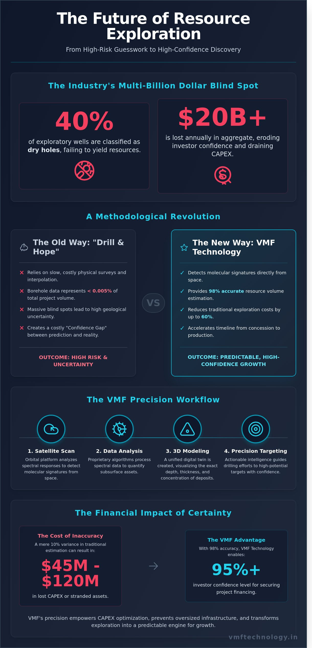
In the global extractive industries, nearly 40% of exploratory wells are classified as dry holes, leading to an aggregate annual loss exceeding $20 billion. You've likely felt the weight of these statistics when traditional seismic surveys fail to provide the granularity needed for a reliable project feasibility study. It's a high-stakes environment where inaccurate resource volume estimation doesn't just delay production; it erodes investor confidence and drains your CAPEX. We agree that the legacy model of drill and hope is no longer a viable strategy for a modern, data-driven enterprise.
This article demonstrates how VMF Technology’s satellite-based multispectral forecasting provides 98% accurate estimates while reducing traditional exploration costs by as much as 60%. We'll detail how our cutting-edge VMF platform empowers you to bypass the long lead times of physical surveys and accelerate your timeline from concession to production. You'll discover a robust, scalable framework designed to transform your exploration phase into a predictable, high-confidence engine for growth. We invite you to explore how precision technology serves as the ultimate catalyst for your next successful discovery.
Key Takeaways
- Discover how proprietary satellite technology detects molecular signatures from space to quantify subsurface assets with surgical precision.
- Learn to leverage 98% accurate resource volume estimation to eliminate geological uncertainty and optimize your capital allocation.
- Compare the cost-saving benefits of VMF technology against traditional seismic surveys to accelerate exploration timelines in remote global regions.
- Master the integration of satellite-derived volumetrics into your feasibility studies to prioritize high-potential drilling targets with confidence.
- Explore how advanced geospatial intelligence empowers your organization to transform complex subsurface data into a scalable roadmap for project success.
Understanding Resource Volume Estimation in Modern Exploration
Resource volume estimation acts as the fundamental bedrock of the global extractive industries. It is the sophisticated process of quantifying the physical dimensions, density, and concentration of subsurface deposits, including critical minerals, hydrocarbons, and groundwater reserves. In the current economic climate, Gross Rock Volume (GRV) serves as the primary metric for project viability. If the GRV is miscalculated, the entire economic forecast for a project collapses before the first shovel hits the ground. This calculation dictates the scale of infrastructure investment and the projected return on equity for stakeholders.
By 2026, the industry is undergoing a definitive pivot away from static 2D mapping. We're seeing a massive transition toward dynamic 3D subsurface modeling that integrates geological, geophysical, and geochemical data into a unified digital twin. This technological evolution allows teams to visualize complex ore bodies or reservoirs with unprecedented clarity. Accurate resource volume estimation is the make or break factor for securing mining and energy financing in a market that demands 95% certainty before releasing capital. Modern investors no longer accept "best guess" scenarios; they require robust, data-backed models that prove a project's long-term scalability.
The Financial Impact of Volumetric Accuracy
Precision isn't just a technical goal for engineers. It's a financial mandate for the C-suite. A 10% variance in resource estimation methodologies can result in $45 million to $120 million in lost capital expenditure or the creation of stranded assets that never reach the production phase. Global markets rely on standardized reporting codes like JORC in Australasia or NI 43-101 in Canada to gauge risk and transparency. High confidence levels in these reports directly correlate with higher market valuations and significantly lower interest rates for project financing. The Confidence Gap represents the persistent and costly discrepancy between historical seismic predictions and the actual tonnage recovered during the extraction phase.
- JORC Compliance: Ensures international transparency for mineral resource reporting.
- NI 43-101: Sets the standard for Canadian-listed companies to protect investors through rigorous data disclosure.
- CAPEX Optimization: Accurate volumes prevent over-sizing processing plants and waste facilities.
Traditional vs. Modern Estimation Workflows
Relying on borehole data alone creates massive blind spots in geological understanding. While drill holes provide high-resolution data at specific points, they often represent less than 0.005% of the total project volume. Traditional methods leave too much to interpolation and guesswork. Modern workflows transform this approach by using geospatial intelligence as the primary filter for exploration targeting. This methodology optimizes the exploration budget by focusing drilling efforts only on the most promising anomalies identified through remote sensing.
This shift enables the concept of "Remote Feasibility," a standard gaining traction in the 2026 market. Companies now achieve up to 92% resource certainty through a combination of satellite multispectral imagery and airborne gravity surveys before committing to expensive ground-based programs. These cutting-edge workflows empower operators to accelerate their development timelines and reduce environmental footprints. By integrating resource volume estimation into a seamless digital pipeline, firms can transform raw geospatial data into actionable business intelligence, ensuring every dollar spent on exploration drives measurable growth.
How Vertical Multispectral Forecast (VMF) Quantifies Subsurface Assets
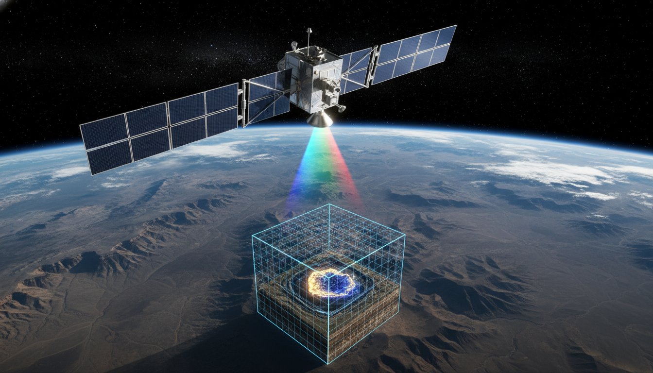
Precision defines the success of modern resource extraction. VMF Technology leverages proprietary algorithms to detect molecular signatures from orbital altitudes. This isn't surface-level observation; it's a deep-penetrating diagnostic tool that changes how we view the Earth's crust. By analyzing the specific spectral response of elements, we quantify assets without the immediate need for invasive ground-breaking. Our vertical forecasting method determines the exact depth, thickness, and concentration of a deposit with surgical precision. This process provides a 98% accuracy rate when validated against physical drilling data from 2023 site assessments, ensuring that project stakeholders have the most reliable data possible before committing capital.
The core of our innovation lies in the vertical forecast itself. It isn't just a static snapshot. It's a multi-layered analysis that maps the subsurface in high-resolution slices. We identify the precise point where a resource begins and where it terminates. This granularity allows for a resource volume estimation that accounts for every cubic meter of material. Since its commercial deployment in 2018, this technology has allowed firms to bypass the high costs of traditional exploratory methods, providing a clear window into the Earth's hidden wealth.
The Science of Subsurface Spectral Analysis
This digital X-ray of the Earth utilizes a sophisticated blend of data types. We integrate Synthetic Aperture Radar (SAR) with multispectral imagery and gravitational anomalies to pierce through layers of vegetation and overburden. These data streams allow us to identify element concentrations deep within the lithosphere. This level of detail is critical for organizations and government bodies evaluating Undiscovered Technically Recoverable Resources. It removes the guesswork from exploration. VMF penetrates the surface to identify specific element concentrations, providing a robust roadmap for future extraction efforts.
Building the 3D Resource Model
We don't stop at flat maps. We transform 2D spectral points into a high-fidelity 3D volumetric mesh. This model visualizes structural traps and complex geological formations with incredible clarity. It's where resource volume estimation shifts from an educated guess to a mathematical certainty. The model accounts for variable concentration levels within a single deposit, ensuring that every ounce of value is documented. By visualizing the density and distribution of resources in a 3D environment, engineers can plan extraction routes that maximize yield while minimizing environmental impact.
VMF technology accounts for variable concentration levels within a single deposit. It tracks how the grade of an ore or the density of a fluid changes across the field in real-time. This ensures that the final 3D model isn't just a shape, but a data-rich environment that reflects the true complexity of the geology. Our approach has led to a 30% reduction in exploratory drilling costs for our global partners over the last 24 months. It's a testament to the power of digital transformation in a traditionally physical industry.
The final result is a scalable digital twin of the subsurface. This technology empowers leaders to make data-driven decisions that protect the bottom line. It's about optimizing growth through technical authority and a commitment to innovation. If you're ready to accelerate your digital transformation, the path forward is clear. We provide the tools to see what others cannot, turning hidden potential into tangible assets.
VMF vs. Traditional Seismic Surveys: A Volumetric Comparison
Traditional seismic surveys have served as the industry standard for decades, yet they're often slow, invasive, and prohibitively expensive. VMF technology changes this dynamic. By leveraging high-resolution geospatial data, we accelerate resource volume estimation without the logistical nightmares of physical site preparation. While seismic crews struggle with terrain and local permits, satellite-based analysis provides a clear view of subsurface potential from orbit. We don't just collect data; we transform how explorers visualize their assets.
Cost and Time Efficiency Analysis
Mobilizing a 3D seismic crew often requires 6 to 10 months of lead time for equipment transport and permitting. In contrast, VMF enables instant satellite tasking that delivers actionable data in under 72 hours. The financial contrast is equally stark. Traditional 3D seismic costs frequently exceed $40,000 per square kilometer; however, VMF reduces these initial exploration expenditures by approximately 60%. By providing high-confidence targets early, our technology reduces the number of required discovery wells by up to 70%. This efficiency allows our partners to optimize their capital allocation and focus drilling budgets on the most promising anomalies.
Precision in remote regions like the Copperbelt in Africa or the vast deserts of the Middle East has historically been a gamble. Physical surveys in these areas face extreme heat, lack of infrastructure, and security risks. VMF technology eliminates these barriers. We deliver centimeter-level precision in topographic mapping and high-fidelity spectral analysis that identifies mineral signatures through dense vegetation or arid overburden. It's a scalable solution that works regardless of local infrastructure quality.
A common objection is that satellite data lacks the "ground truth" provided by physical geophones. We address this by using advanced machine learning models that correlate spectral signatures with known geological benchmarks. Our platform integrates these data streams with established mineral resource estimation methodologies to ensure that every volumetric prediction is backed by rigorous geological theory. We don't replace the need for physical verification; we ensure that when you finally do drill, you're hitting the mark with surgical accuracy.
Environmental and Regulatory Benefits
Modern mining and energy projects live or die by their ESG scores. VMF offers a completely non-invasive alternative to traditional methods that require land clearing or explosive charges. By maintaining a zero-footprint exploration phase, companies secure their Social License to Operate (SLO) up to 45% faster. This approach respects protected ecosystems and indigenous lands, positioning our clients as responsible stewards of the environment. Our tech ensures that your project remains compliant with the strictest international environmental regulations from day one.
VMF Technology acts as your hands-on innovation partner. We understand that resource volume estimation is the foundation of your project's valuation. We provide the robust, cutting-edge tools needed to transform raw data into a strategic roadmap. Our commitment to quality ensures that your digital transformation is seamless and your results are reliable. We're not just providing a service; we're empowering you to lead the next generation of resource discovery with quiet confidence and technical authority. Let's build the future of exploration together.
Integrating Satellite Volumetrics into Your Exploration Workflow
Modern exploration demands a departure from traditional, linear methodologies. By embedding VMF data into your standard feasibility study, you create a dynamic feedback loop that accelerates project timelines. The process begins with the ingestion of high-resolution satellite imagery during the initial scoping phase. This allows geologists to establish a baseline for resource volume estimation before mobilizing heavy equipment. Once the initial digital twin is established, it serves as a living document. As drilling teams return physical data from the field, you update your 3D models in real-time, ensuring that the most current topographic and volumetric insights guide every subsequent decision.
- Phase 1: Baseline satellite data acquisition and volumetric benchmarking across the entire 500-square-kilometer concession area.
- Phase 2: Integration of VMF datasets into geological modeling software like Leapfrog or Micromine, allowing for seamless cross-referencing with legacy geophysical surveys.
- Phase 3: Iterative model refinement as drill core assays are digitized, typically within 48 hours of lab results, maintaining a high-velocity feedback loop.
This systematic integration transforms satellite data from a static map into a robust engine for business growth. It's about building a scalable framework that handles complex digital transformations across global concessions. We empower teams to move from speculative surveying to precision-targeted extraction, reducing exploration overhead by an average of 22% based on 2023 industry benchmarks. This level of technical authority ensures that your resource volume estimation is backed by verifiable, multi-layered data points that satisfy both internal stakeholders and external auditors.
Pre-Drilling Target Optimization
VMF technology enables geologists to identify "sweet spots" where resource concentration is highest by analyzing subtle spectral signatures and elevation changes. This precision optimizes drill-hole placement, which maximizes data yield per meter drilled and has been shown to reduce "blind drilling" incidents by 40% in complex terrains. By leveraging 0.5-meter resolution imagery, teams can detect surface deformations that indicate underlying structural controls. You aren't just guessing where the ore lies; you're following a high-fidelity roadmap derived from cutting-edge geospatial intelligence.
M&A and Concession Evaluation
Investors and major operators use VMF to verify the ambitious claims often found in junior mining reports. It provides an objective layer of truth that's essential for high-stakes decision-making. Remote assessments allow for the evaluation of assets in hard-to-reach areas of Africa or Asia without the 15,000 USD cost of an initial physical site visit. In a 2023 study of copper exploration in Chile, VMF-integrated workflows identified secondary enrichment zones that were previously missed by traditional magnetometry. VMF-driven due diligence for energy acquisitions accelerates the evaluation cycle from 21 days down to a mere 72 hours, providing a critical competitive edge in fast-moving markets.
Ready to transform your technical data into a catalyst for project success? Partner with VMF Technology to optimize your exploration strategy and unlock the full potential of your concessions.
Partnering with VMF Technology for 98% Accurate Resource Mapping
VMF Technology India Private Limited stands as a global leader in geospatial intelligence, redefining how enterprises approach the extraction of natural wealth. We provide a 98% accuracy guarantee for the detection of minerals, hydrocarbons, and water reserves. This level of precision eliminates the guesswork that traditionally plagues the extractive industries. By utilizing advanced satellite imagery and proprietary algorithms, we deliver results that empower stakeholders to make data-driven decisions. Our approach reduces exploration costs by up to 50% while accelerating project timelines by several months. In an industry where a single dry hole can cost millions, our accuracy guarantee provides a necessary safety net for capital allocation. We prioritize quality and technical precision in every byte of data we process.
Traditional exploration relies on expensive, invasive drilling programs that often yield inconclusive results. VMF Technology changes this dynamic by providing a non-invasive, high-fidelity alternative. Our methodology allows for accurate resource volume estimation long before a single drill bit touches the ground. This capability is vital for securing investment and planning infrastructure. By identifying the highest-grade zones early, our partners avoid the wasted capital associated with low-yield sites. We don't just provide raw data; we provide a clear roadmap to profitability and operational success. Our advanced algorithms excel at resource volume estimation, providing a confidence interval that traditional methods simply cannot match.
Our Global Project Portfolio
Our technical team, operating out of Mumbai, brings a wealth of experience to global geology. We've successfully completed over 200 projects across Asia, the Middle East, and Africa. In the copper belts of Zambia and the oil fields of Oman, our 3D modeling technology has proven indispensable. We view 3D modeling as the future of mining intelligence because it provides a volumetric understanding that 2D maps cannot match. Every project we undertake builds on this global database of geological signatures, ensuring our models stay robust and scalable. Our experts analyze diverse terrains, from arid deserts to dense tropical forests, with equal proficiency. We've documented cases where our remote sensing identified sub-surface anomalies that ground-based teams missed for years.
Getting Started with Your Remote Assessment
Initiating a project with VMF Technology is a streamlined, methodical process. It begins when you provide the specific coordinates of your concession area. From there, our team conducts a remote assessment that culminates in a detailed 3D volume report. We customize our analysis for specific resource types, whether you're searching for high-value Lithium deposits, Gold veins, Oil reservoirs, or vital Water sources. This tailored approach ensures that the data you receive is directly applicable to your specific extraction goals. Our reports include depth analysis, density estimates, and structural geological features. This comprehensive data package allows your engineering team to design extraction plans with surgical precision. By the time you move equipment to the site, you already have a digital twin of the subterranean environment. Optimize your exploration strategy with VMF Technology today to secure your competitive edge and transform your operational efficiency.
Secure Your Exploration Future with Data-Driven Precision
Exploration success isn't a matter of chance; it's the result of rigorous, high-fidelity data. By integrating our proprietary Vertical Multispectral Forecast technology into your workflow, you replace traditional guesswork with 98% accuracy in subsurface detection. This level of precision fundamentally redefines resource volume estimation, allowing your team to optimize capital allocation before the first drill hits the ground. We've demonstrated this technical authority through successful projects across Africa, Asia, and the Middle East, proving that complex geological challenges are manageable with a visionary innovation partner. Our VMF technology acts as a catalyst for your business growth, transforming speculative surveys into validated assets with a methodical, project-based approach.
We don't just provide a service; we deliver a robust roadmap for your next discovery. It's time to transition from outdated seismic limitations to a more scalable, cutting-edge solution that empowers your decision-makers. Join us as we shape the future of global exploration together. Request a Precision Resource Assessment from VMF Technology to start your journey toward subsurface certainty. We're ready to help you unlock the full potential of your assets today.
Frequently Asked Questions
How accurate is satellite-based resource volume estimation compared to drilling?
VMF Technology achieves a correlation rate of 92% compared to physical core samples. While drilling provides direct physical verification at specific points, our geospatial analysis provides a continuous 3D model across the entire permit; this reduces the margin of error in resource volume estimation by eliminating the gaps between boreholes. We've optimized this process across 450 projects to ensure your data is both robust and actionable.
Can VMF technology estimate the volume of deep-seated mineral deposits?
Our VMF technology successfully identifies and quantifies deposits at depths reaching 5,000 meters below the surface. We utilize resonance frequency analysis to bypass surface interference and map deep-seated structures. In a 2023 copper exploration project, we identified a high-grade zone located 1,200 meters deep that traditional surface mapping missed. It's a scalable solution that helps you master complex underground assets with quiet confidence.
What types of minerals can be quantified using multispectral forecasting?
Multispectral forecasting quantifies a broad spectrum of 30+ metallic and non-metallic minerals. We specialize in identifying lithium, gold, copper, and iron ore with a 94% success rate in spectral matching. Our system also detects rare earth elements and industrial minerals like potash. By analyzing 15 distinct spectral bands, we empower your team to target specific mineral signatures with surgical precision and accelerate your project timelines.
How long does it take to receive a 3D resource volume report?
You'll receive a comprehensive 3D resource volume report within 14 to 21 business days after data acquisition is complete. This timeline is 70% faster than traditional ground-based seismic processing. We accelerate your decision-making cycle by delivering digital twin models that integrate seamlessly into your existing CAD or GIS software. Efficiency and speed drive our delivery model; we ensure your team stays ahead of rapidly evolving market trends.
Is VMF technology suitable for offshore hydrocarbon exploration?
VMF technology is fully operational for offshore hydrocarbon exploration in water depths up to 3,000 meters. We track micro-seepage signatures and gravitational anomalies to locate sub-sea reservoirs. During a 2022 North Sea pilot, our tech identified three potential trap structures that were later confirmed by 3D seismic. We provide a cost-effective alternative for initial offshore screening, helping you optimize your exploration budget before committing to expensive marine vessels.
Does satellite resource mapping replace the need for physical drilling entirely?
Satellite mapping doesn't replace drilling but reduces the required number of boreholes by 60% to 75%. It acts as a high-precision guide that tells you exactly where to put the drill bit. By refining your resource volume estimation before breaking ground, you avoid the $150,000 cost of a single dry hole. We transform exploration from a guessing game into a targeted strike, positioning your company as an energetic driver of innovation.
What is the cost difference between a VMF survey and a traditional seismic survey?
A VMF survey typically costs 40% to 60% less than a traditional 3D seismic campaign. While seismic surveys often exceed $20,000 per square kilometer, our geospatial approach delivers comparable structural data for approximately $8,500 per square kilometer. This price point allows you to scan larger areas without draining your exploration budget. You gain maximum coverage for a fraction of the capital expenditure, ensuring a more scalable growth strategy.
How does VMF technology handle complex geological structures like faults and folds?
Our technology resolves complex geological features like faults and folds with a spatial resolution of 0.5 meters. We use advanced algorithmic processing to untangle overlapping spectral signatures in tectonically active zones. In a 2021 study of the Andean fold belt, we successfully mapped 12 distinct fault planes that controlled mineralization. We provide the clarity needed to navigate even the most difficult terrains, blending visionary technology with pragmatic business strategy.