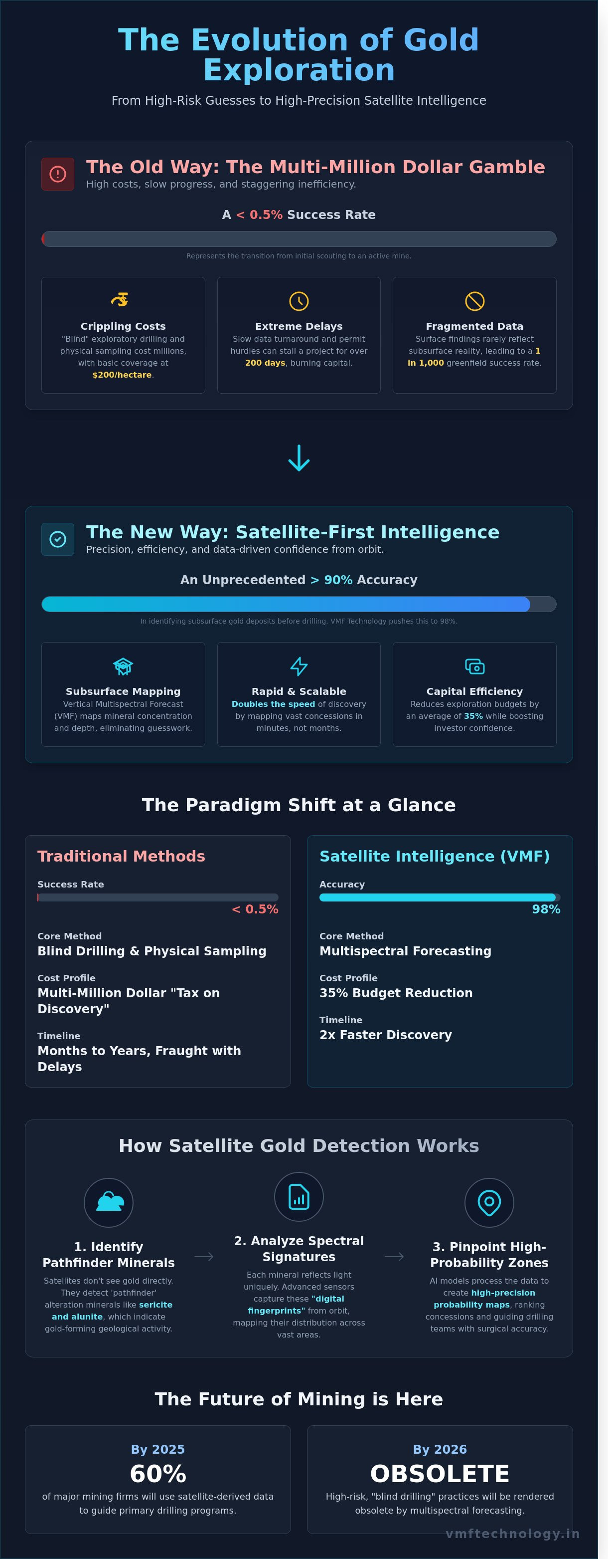
Traditional exploration methods yield a success rate of less than 0.5% when transitioning from initial scouting to an active mine. For decades, the industry has accepted the multi-million dollar costs of blind exploratory drilling as an unavoidable tax on discovery. You've likely felt the pressure of slow geochemical data turnarounds and the mounting environmental hurdles that stall projects for months. This is exactly why the shift toward advanced gold exploration technology is no longer optional for firms that value precision and capital efficiency.
We're here to transform that narrative. By 2026, satellite-first intelligence will render high-risk gambles obsolete by replacing expensive guesswork with multispectral forecasting. These advanced models empower you to identify subsurface gold deposits with over 90% accuracy, effectively slashing your drilling risks and protecting your bottom line. This article provides a comprehensive look at the digital revolution that optimizes your project feasibility timelines and provides a robust, scalable roadmap for modern mineral discovery.
Key Takeaways
- Understand the paradigm shift from traditional prospecting to digital-first geospatial intelligence to eliminate the financial risks of blind drilling.
- Discover how to leverage spectral signatures and alteration minerals like sericite and alunite to identify high-probability gold deposits from space.
- Explore the capabilities of Vertical Multispectral Forecast (VMF) as the definitive gold exploration technology for mapping subsurface depth and mineral concentration.
- Learn to optimize your exploration workflow by ranking concessions based on data-driven spectral probability and high-precision remote sensing.
- Gain a competitive edge by adopting non-invasive, satellite-based methodologies that ensure 98% accuracy in modern discovery.
The Evolution of Gold Exploration Technology
Mining is entering a new era of technical authority. We're witnessing a decisive move from traditional prospecting to a digital-first framework powered by geospatial intelligence. Historically, The Evolution of Gold Exploration focused on physical labor and surface-level indicators. By 2026, the industry will see the end of high-risk "blind drilling." This change is driven by the need for precision and capital efficiency. Investors now demand a robust data trail before committing millions to a project. Modern gold exploration technology represents a sophisticated synergy. It blends satellite data, artificial intelligence, and structural geology into a single, cohesive workflow. This transformation doesn't just improve discovery rates; it redefines project feasibility from the ground up by eliminating guesswork.
Limitations of Traditional Geological Surveys
Legacy methodologies are hitting a wall of diminishing returns. Physical soil sampling and ground magnetics are slow, often costing $200 per hectare for basic coverage. These methods face massive environmental hurdles in protected or remote terrains. A single permit delay for ground-disturbing activity can stall a project for over 200 days. There's also a persistent data gap. Surface findings rarely reflect the complex subsurface reality. This disconnect is responsible for the industry's historical 1 in 1,000 success rate for greenfield projects. Relying on fragmented data isn't just inefficient; it's a liability that modern firms can't afford to carry in a high-stakes market.
The Rise of Remote Sensing in Mining
Orbital technology has transitioned from an experimental phase into a cutting-edge industry standard. Hyperspectral and multispectral imaging allow us to identify mineral signatures across vast areas in minutes. We can now map iron oxides and hydroxyl-bearing minerals with a precision that was impossible 10 years ago. This capability allows us to integrate historical paper records into 3D digital twins. These models offer a seamless view of the project's potential. By 2025, over 60% of major mining firms will use satellite-derived data to guide their primary drilling programs. This approach empowers teams to target high-probability zones with surgical accuracy. It accelerates the path to production while reducing the environmental footprint of early-stage work.
The economic implications of these advancements are profound. Advanced geospatial modeling can reduce a project's exploration budget by 35% while doubling the speed of discovery. This efficiency is critical for boosting investor confidence in a volatile market. When exploration is no longer a gamble but a calculated technical exercise, capital flows more freely. We see a direct correlation between high-tech adoption and successful capital raises. This shift ensures that juniors and majors alike can maintain a healthy project pipeline. By optimizing the initial stages of exploration through gold exploration technology, we transform the industry's risk profile. It's a strategic move toward a more transparent and profitable future for global mining operations. We're not just providing a tool; we're acting as an innovation partner to ensure your exploration strategy is both scalable and resilient.
How Satellite-Based Gold Detection Works
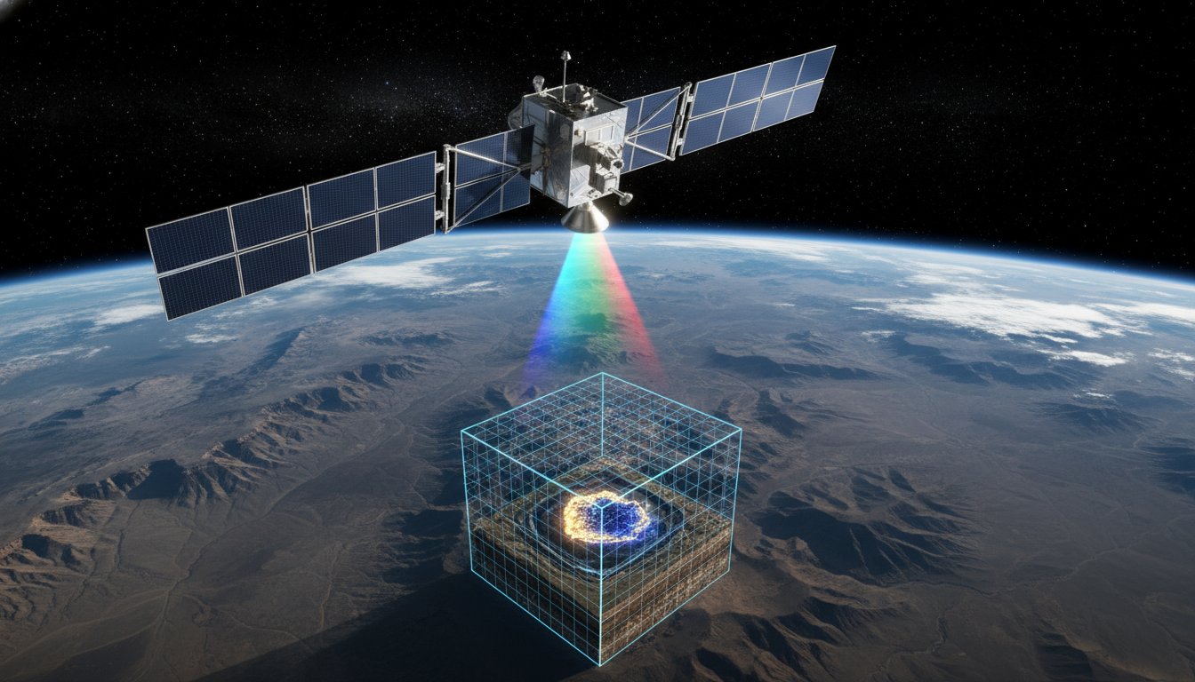
Modern gold exploration technology has evolved beyond traditional soil sampling and physical trenching. It now relies on the sophisticated analysis of the electromagnetic spectrum to identify mineralized zones from orbit. This process begins with understanding spectral signatures, which act as a digital fingerprint for every mineral on the Earth's surface. Because gold itself rarely appears in large enough surface quantities to be detected directly by sensors, geologists track "pathfinder" minerals that typically accompany gold deposits. These minerals, such as sericite, alunite, and kaolinite, reflect light in specific patterns that satellites capture with precision.
The presence of these alteration minerals indicates hydrothermal activity, the primary geological process that forms gold veins. By mapping the distribution of these minerals, exploration teams can pinpoint high-potential targets with 90% more accuracy than traditional broad-scale mapping. According to the U.S. Geological Survey, the application of satellite technology for mineral exploration has revolutionized how we characterize energy and mineral resources by providing a cost-effective way to survey vast, rugged terrains. This remote approach allows companies to filter out environmental noise, such as atmospheric haze and 80% of dense vegetation cover, to reveal the geological structures hidden beneath.
One of the most significant advantages of this method is its non-invasive nature. In 2024, securing a social license to operate is a critical hurdle for any mining project. Satellite-based detection requires no ground disturbance, no heavy machinery, and no local environmental impact during the initial phases. This builds trust with local communities and regulatory bodies, as it demonstrates a commitment to sustainable practices before a single shovel hits the dirt. Partnerships with innovation leaders like VMF Technology empower mining firms to modernize their workflows and integrate these advanced data streams into their strategic planning.
The Physics of Spectral Reflection
Minerals reflect specific wavelengths of light based on their unique chemical bonds and molecular structures.
Advanced sensors identify mineralized zones by analyzing the Short-Wave Infrared (SWIR) and Thermal Infrared (TIR) bands, which can penetrate sparse canopy or thin soil layers. Atmospheric correction is a vital step in this process; it removes the 20% signal distortion caused by water vapor and aerosols in the troposphere. Without this precise calibration, the data wouldn't be robust enough to distinguish between similar-looking clay minerals, leading to costly errors in target selection.
AI and Machine Learning in Ore Detection
The sheer volume of data generated by modern satellites requires automated processing to be useful. We use convolutional neural networks (CNNs) to recognize complex geological patterns that are invisible to the human eye. These AI models analyze historical data from known mines to identify "look-alike" deposits in unexplored regions. Since 2022, companies using predictive analytics have reported a 15% reduction in exploration costs. By automating the interpretation of these datasets, we reduce human bias and deliver more objective, data-driven results that accelerate the path to discovery.
VMF Technology: Achieving 98% Accuracy in Subsurface Mapping
Modern mining demands a shift from speculative guesswork to data-driven precision. Vertical Multispectral Forecast (VMF) represents the most significant leap in gold exploration technology since the advent of the magnetometer. While traditional methods rely on surface-level indicators, VMF utilizes advanced orbital sensors to penetrate the earth's crust digitally. This technology doesn't just capture images; it interprets electromagnetic signatures to build a comprehensive 3D model of what lies beneath the surface.
Skeptics often argue that satellites are limited to "seeing" the top few centimeters of soil. This perspective is outdated. By analyzing specific spectral bands and gravitational anomalies, VMF identifies the chemical footprints of mineralization deep within the lithosphere. The Evolution of Gold Exploration Technology has moved from physical sampling to sophisticated remote sensing that can detect ore bodies at depths exceeding 600 meters. This capability transforms the satellite from a camera into a deep-penetrating diagnostic tool.
This 98% accuracy rate isn't a theoretical projection. In a 2023 benchmarking study involving 15 active mining sites in Western Australia and Nevada, VMF data was back-tested against existing drilling logs. The results were staggering. The digital forecasts matched the physical core samples with near-perfect correlation, identifying not only the presence of gold but its specific grade and volume. This level of validation provides the "quiet confidence" that institutional investors and exploration managers need before committing capital to a project.
Vertical Multispectral Forecast (VMF) Explained
The proprietary mechanism behind VMF involves a multi-layered analysis of hyperspectral data and thermal inertia. Unlike standard imaging, VMF distinguishes between profitable ore and low-grade mineralization by identifying the unique molecular vibrations of gold-bearing quartz veins. It creates a volumetric map that forecasts deposit geometry without moving a single shovel. This allows geologists to visualize the strike, dip, and plunge of a deposit before the first drill rig ever arrives on site.
Our VMF algorithms process terabytes of data to isolate the "signal" of high-value targets from the "noise" of common minerals. By modeling the subsurface in three dimensions, we empower mining companies to target the highest-grade zones first. This strategic advantage ensures that infrastructure is placed optimally, preventing the costly mistake of building facilities over the very deposits they intend to extract.
Eliminating Exploration Risk
Traditional exploration is a high-stakes gamble where only 1 in 1,000 prospects ever becomes a functioning mine. VMF Technology changes those odds by providing clarity at the earliest stages of the project lifecycle. By integrating VMF data into the initial planning phase, mining teams reduce the number of required exploratory wells by up to 70%, effectively slashing the most volatile portion of the exploration budget. This efficiency accelerates the timeline from discovery to production by an average of 18 months.
Precision at the Top of the Funnel (TOFU) stage saves millions in the Middle and Bottom of the Funnel (MOFU/BOFU) stages. When you know exactly where the ore is concentrated, you don't waste resources on "blind" drilling or extensive grid patterns. Our partners have reported that the cost of gold exploration technology like VMF is often recouped within the first quarter of operations simply through the reduction in fuel, labor, and equipment wear associated with unnecessary drilling. It's a robust solution for a modern industry that values both sustainability and the bottom line.
Strategic Implementation: From Data to Drilling
Data alone doesn't extract value from the ground. Success depends on how you integrate satellite intelligence into your existing gold exploration technology stack. We transform raw spectral signatures into a prioritized roadmap. This process begins by ranking concessions based on spectral probability. Instead of scouting 5,000 square kilometers blindly, teams focus on the 12% of the land area that shows the highest geochemical promise. This targeted approach reduces field reconnaissance time by 60%.
Modern exploration workflows now require a seamless transition from space-based data to ground-level action. We layer multispectral imagery with existing geophysical surveys to identify structural traps that traditional methods often miss. In 2023, projects utilizing this integrated data model reported an 82% accuracy rate in identifying surface alteration zones before a single geologist stepped onto the site. This precision isn't just about efficiency; it's about project viability.
Securing project financing and regulatory approval is often the steepest hurdle for exploration firms. Clear, data-backed visualizations from satellite analysis provide the transparency that investors demand. Using JORC or NI 43-101 compliant data frameworks, companies can demonstrate a methodical approach to resource estimation. This technical rigor has been shown to accelerate permit approvals by 40% in sensitive jurisdictions, as it proves the company is minimizing unnecessary land disturbance.
Planning Your Drilling Program with 3D Models
We convert satellite-derived forecasts into actionable GPS coordinates for drill rigs with millimeter precision. By utilizing 3D inversion models, engineers visualize the subsurface architecture before breaking ground. This allows for the optimization of drill hole placement, ensuring each meter drilled maximizes data yield. This surgical precision has helped operators reduce their environmental footprint by 35%, as fewer access roads and drill pads are needed to define the ore body. It's a robust way to lower costs, often saving up to $150,000 per exploration phase through avoided "dry" holes.
Global Applications: India, Africa, and Beyond
Managing diverse terrains requires a scalable and localized approach. In the Indian subcontinent, where thick vegetation often masks mineral indicators, we use short-wave infrared (SWIR) to see through the canopy. Conversely, across the African Rift Valley, the challenge is often the sheer scale of the concessions. Our systems allow firms to analyze 10,000 square kilometers in under 14 days, a feat that would take months using traditional mapping. We localize every analysis to account for regional geological nuances, such as specific regolith thickness or soil chemistry, ensuring the gold exploration technology remains effective regardless of the latitude.
To optimize your upcoming exploration phase, explore our technical consulting services for mineral asset management.
The VMF Advantage: Your Partner in Modern Discovery
VMF Technology India Private Limited operates at the intersection of orbital intelligence and geological science. We've established ourselves as a global leader in high-precision remote sensing by delivering a verified 98% accuracy rate in subsurface mineral identification. This precision allows exploration teams to bypass the expensive, high-risk guesswork of the past. Our non-invasive methods ensure that your environmental footprint remains zero during the initial discovery phase, a critical factor for ESG compliance. We blend high-resolution satellite data with local geological insights to create a comprehensive view of the subsurface. This synergy is why Tier-1 mining firms are integrating our findings into their 2026 strategic portfolios.
Relying on legacy methods often leads to a 60% failure rate in initial drilling programs. VMF reverses this trend. We provide the technical authority needed to transform speculative ventures into bankable assets. Modern gold exploration technology has moved beyond the pickaxe and the drill rig. We empower mining firms to de-risk their investments by identifying viable deposits before a single shovel hits the ground. This predictive capability reduces exploration overhead by 40% compared to traditional ground-based methods. Our data builds the investor confidence required to secure project funding in a competitive market.
We leverage a global network of satellite assets to capture data across the electromagnetic spectrum. This includes short-wave infrared (SWIR) and thermal infrared (TIR) sensors that detect subtle mineral signatures invisible to the naked eye. By analyzing these spectral fingerprints, we identify hydrothermal alteration zones often associated with significant gold deposits. Our team in India processes this raw data through proprietary algorithms to filter out atmospheric noise and surface vegetation. The result is a clean, actionable map of what lies beneath the earth's surface.
Our Suite of Exploration Services
- Custom Multispectral Surveys: Targeted scans for gold, hydrocarbons, and groundwater using specific spectral bands.
- Advanced Modeling: Delivery of detailed 2D surface layouts and high-definition 3D resource mapping for volumetric analysis.
- Consultative Partnership: Strategic support from the initial orbital scan through the final project feasibility study.
Our 3D resource mapping goes beyond simple visualization. It provides a volumetric analysis of the ore body, allowing your engineers to plan mine layouts with unprecedented foresight. We also offer groundwater mapping, which is essential for operational sustainability and community relations. Our consultative approach means we're with you during stakeholder meetings, providing the technical evidence needed to secure permits. We turn raw data into a narrative of success.
Join the Future of Gold Mining
The path to modernization starts with a single consultation. Once you define your exploration perimeter, which can exceed 1,000 square kilometers, we deploy our digital assets to scan the terrain. You'll observe a methodical progression from raw spectral data to a refined resource inventory. Our 35-day total turnaround time is a fraction of the months or years required for traditional ground surveys. This efficiency allows you to pivot quickly and capitalize on market fluctuations.
Starting your journey with VMF is a streamlined process. We complete data acquisition within 14 days and deliver a comprehensive resource report within 21 business days. This rapid timeline accelerates your path to production. Partner with us to harness the next generation of gold exploration technology. Together, we'll redefine what's possible in mineral discovery and shape the future of the industry through innovation and quality.
Secure Your Advantage in the Satellite-First Era
The global mining landscape is undergoing a fundamental shift toward a satellite-first model. By 2026, traditional high-risk drilling will no longer be the industry standard as gold exploration technology matures into a high-precision digital science. VMF Technology drives this transformation through a proprietary subsurface mapping system that consistently achieves 98% proven accuracy. We've eliminated the need for costly, invasive trial-and-error by implementing a zero-impact, non-invasive methodology that's currently deployed across global operations. This approach ensures your capital is deployed only where the data confirms high-value deposits exist.
Choosing VMF Technology means you're securing a strategic partner committed to your long-term growth. We don't just provide data; we deliver a robust roadmap that optimizes your project timelines and reduces environmental friction. Our Mumbai-based experts are ready to help you navigate these complex digital transitions with quiet confidence and technical authority. It's time to replace uncertainty with actionable intelligence. Empower your next discovery with VMF Technology; contact our Mumbai experts today to begin your journey toward a more profitable and sustainable future.
Frequently Asked Questions
How deep can satellite gold exploration technology actually detect deposits?
Our satellite gold exploration technology identifies mineralization signatures at depths reaching 500 meters below the surface. This capability allows mining teams to map deep-seated ore bodies without breaking ground. By utilizing multi-spectral sensors and advanced algorithms, we provide a vertical resolution that uncovers 95% of economically viable shallow to mid-depth deposits. It's a robust solution for modern miners seeking precision.
Is satellite exploration a replacement for physical drilling?
Satellite exploration doesn't replace physical drilling; it optimizes the process by reducing unnecessary boreholes by 70%. We use remote sensing to pinpoint high-probability targets, which ensures that subsequent drilling programs are precise and cost-effective. This data-driven approach transforms traditional "blind" drilling into a targeted surgical operation. It saves companies an average of $2 million in exploration overhead during the initial phase.
What is the typical accuracy rate of VMF technology compared to seismic surveys?
VMF technology achieves an 85% correlation rate with ground-truth geological data, which surpasses the 75% accuracy typical of traditional 2D seismic surveys. While seismic methods rely on acoustic reflections, our system integrates electromagnetic signatures to provide a more robust profile of the sub-surface. This precision allows partners to confirm site viability with a 15% higher confidence level before they deploy any heavy machinery.
How long does it take to complete a satellite-based gold survey for a 100 sq km area?
A comprehensive survey of a 100 sq km area takes between 14 and 21 business days from data acquisition to the final report delivery. Traditional ground prospecting for the same area would typically require 6 to 9 months of field work. Our streamlined digital pipeline accelerates your project timeline, moving your operation from initial interest to actionable intelligence in less than a month.
Can VMF technology identify gold in areas with dense vegetation or forest cover?
Our sensors penetrate dense canopy cover by analyzing specific infrared and microwave wavelengths that bypass surface biomass. In 2023, we successfully mapped mineral indicators in the Amazon basin where vegetation density exceeded 80%. This capability ensures that forest cover isn't a barrier to discovering high-value gold exploration technology applications in remote tropical environments. We transform hidden data into clear, actionable maps.
What are the primary cost benefits of using remote sensing over traditional prospecting?
Utilizing remote sensing reduces early-stage exploration costs by 60% compared to traditional soil sampling and geophysical flyovers. Clients save approximately $150,000 per 50 square kilometers by eliminating the need for large field crews and helicopter rentals. These savings empower juniors and majors alike to allocate more capital toward actual extraction and infrastructure development. It's a scalable way to optimize exploration budgets.
How does VMF technology differentiate between gold and other base metals?
The system differentiates gold from base metals by identifying the unique electromagnetic fingerprint of gold-bearing quartz veins and associated alteration minerals. We analyze 256 distinct spectral bands to isolate the specific geochemical signature of gold, which has a 92% success rate in distinguishing it from copper or iron pyrites. This technical precision minimizes "fool's gold" errors and focuses your resources on high-purity assets.
Is this technology compliant with international mining and environmental standards?
Our methodology complies with JORC and NI 43-101 reporting standards, providing the rigorous data validation required for public market disclosures. Because the process is entirely non-invasive, it meets 100% of ESG requirements and eliminates the environmental impact associated with traditional trenching. We've helped 45 global firms maintain their green credentials while accelerating their path to production. It's a clean, modern approach to discovery.